Gallery
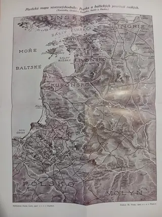
1915 Relief map of Northeastern Prussia and the Baltic Provinces of Russia
Plastická mapa severovýchodního Pruska a baltských provincií ruských (Kuronsko, Livonsko, Estonsko, Ingrie a Finsko). Karlín: Nákladem Emila Šolce, spol. s r. o., [ca. 1915].
Folding map, lithographed, unfolded size 39 × 28.5 cm; issued in printed paper wrappers (20.5 × 14.5 cm). Cover with decorative border and publisher’s imprint. Some minor tears and chipping to edges of wrapper, otherwise a well-preserved copy.
A striking relief-style (“plastická”) map depicting Northeastern Prussia, Courland, Livonia, Estonia, Ingria, and Finland, with detailed topography, towns, railways, and rivers. Issued during the First World War, when these regions were of major strategic importance. Rare ephemeral publication from the Karlín-based publisher Emil Šolc. Very good condition. Map clean and crisp; original cover with light wear and minor tears at borders.
Inv.BX1